2022-2025 Voices of Recovery: Recognising intersecting risks, capacities and pandemic recovery needs in marginalised communities of Latin America
The Trans-Atlantic Platform for Social Sciences and Humanities (T-AP)
Funders Involved: International Development Research Centre (IDRC) grant numbers 109835-003 and 109835-002.; Ministerio de Ciencia, Tecnología e Innovación (MINCIENCIAS) y Fondo Francisco José De Caldas grant number 80740-094-2022; Sao Paulo Research Foundation (FAPESP) grant number 2021/07660-2; and Arts and Humanities Research Council (AHRC) grant number AH/X001733/1.
Lead PI: Professor Roger Few (University of East Anglia), UK (UKRI-ESRC)
PIs:
Dr Liana O. Anderson (CEMADEN), Brazil (FAPESP)
Dr Nelvia Victoria Lugo Agudelo (Universidad de Caldas), Colombia (MINCIENCIAS)
Dr María Eugenia Ulfe (Pontificia Universidad Católica del Perú), Perú (IDRC)
Voices of Recovery’ is a multi-country, interdisciplinary partnership that focuses on understanding and supporting the recovery needs of socially, politically and physically marginalised communities in Latin America. The project goes much further than posing research questions, and will be rooted in participation and action, using creative arts approaches to strengthen people’s articulation of rights and needs during and after the pandemic.
2022-2024 MapFire-Maranhão: Uma plataforma virtual para a gestão do balanço de carbono entre emissões pelo fogo e remoções por floresta secundárias para o Estado do Maranhão (MAP-MA).
Funding Agency: The São Paulo Research Foundation - FAPESP: 2020/16457-3 & FAPEMA: 02989/20
PIs: Liana Oighenstein Anderson (Cemaden/FAPESP) and Tiago Massi Ferraz (UEMA/FAPEMA).
Associated Researches:
Swanni T. Alvarado Romero (UEMA)
Luiz Eduardo O.C. Aragão (INPE)
Daniel Borini Alves (UNESP-Rio Claro)
Joao dos Reis (Cemaden)
Ana Carolina Pessôa (INPE)
Nathália de Carvalho (INPE)
Celso Henrique Silva Júnior (UEMA)
Izadora Santos de Carvalho (UEMA)
Resumo
Neste projeto de Pesquisa, portanto, propomos prover um diagnóstico e um sistema para a gestão do balanço de carbono entre emissões pelo fogo e remoções por floresta secundárias na Amazônia legal no estado do Maranhão, a fim subsidiar as medidas de prevenção e controle de queimadas, e assim melhorar a gestão dos recursos naturais e das áreas prioritárias para a conservação e restauração ecológica. Esta proposta está alinhada ao objetivo 15 da Agenda 2030 para o Desenvolvimento Sustentável: "Proteger, restaurar e promover o uso sustentável dos ecossistemas terrestres, gerenciar florestas de forma sustentável, combater a desertificação e deter e reverter a degradação da terra e deter a perda de biodiversidade" (Nações Unidas, 2014). Em nível nacional, a proposta visa contribuir para o desenvolvimento científico e metodológico que podem apontar caminhos para o país alcançar as metas de redução de emissão de CO2 acordadas por meio da Contribuição Nacionalmente Determinada (NDC) ratificada em resposta ao Acordo de Paris.
Objetivo Geral: Prover um diagnóstico e um sistema para a gestão do balanço de carbono entre emissões pelo fogo e remoções por floresta secundárias na Amazônia legal no estado do Maranhão, a fim subsidiar as medidas de prevenção e controle de queimadas, e assim melhorar a gestão dos recursos naturais e das áreas prioritárias para a conservação e restauração ecológica.
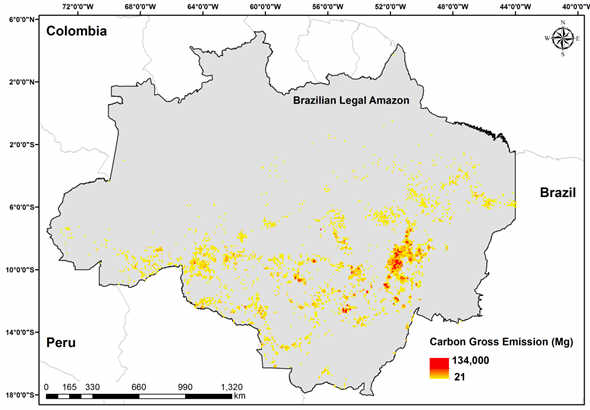
2022-2025 Balanço das emissões brutas de CO2 para o estado do Maranhão
Funding Agency: CNPq - Conselho Nacional de Desenvolvimento Científico e Tecnológico, process number: 409531/2021-9
PI: Liana O. Anderson
Associated Researches:
Celso Henrique Silva Júnior (UEMA)
Swanni T. Alvarado Romero (UEMA)
Denilson da Silva Bezerra (UFMA)
Fabrício Brito Silva (UNICEUMA)
Joao dos Reis (Cemaden)
Taíssa Caroline Silva Rodrigues (UEMA-SUL)
Wesley Campanharo (INPE)
Iniciação científica: Eduarda Vaz Braga (UEMA-SUL)
2022-2023 Attribution and Synopsis of Landslide Impacts from Precipitation (ASLIP)
Funding Agency: Newton Fund (UK)
PIs: Sarah Sparrow (University of Oxford), Sihan Li (University of Oxford), Liana Anderson (Cemaden), Rafael Abreu (USP)
Project summary:
Landslides can cause extensive damage to the built environment, cost human lives and monetary loss. Heavy precipitation not only can trigger landslide occurrence, but also could turn landslides into highly destructive debris flows, shifting debris materials downstream through the river channels, which could cause increased flooding in the lowland regions and agricultural lands. The impacts of landslides vary in space and time and can quickly exceed local capacity to deal with. There have been many previous research efforts to link heavy rainfall with landslide occurrence, quite often through estimating empirical rainfall thresholds or linking precipitation-related indices with landslides for various regions in Brazil. However, the role anthropogenic climate change plays in the rising number of landslides (especially in the densely populated regions of Brazil) still remains unanswered. The work proposed here aims to unpack the relative roles of natural factors and human disturbances in recent high impact landslide events.
Expected outputs:
- Attribution and Impact Workshop
- Manuscript/report on regional-scale landslide metrics with assessment of the suitability of state-of-the-art earth system models in attribution of landslides co-authored by both UK and Brazilian researchers.
- Dissemination material targeted for civil defence authorities on lessons learnt and research findings in English as well as Portuguese.
2021-2025 Greenhouse Gas Emissions in the Amazon and Data Analytics and Service System - Centro de Pesquisa e Inovação de Gases de Efeito Estufa - RCG2I
PI: Julio Romano Meneghini
FAPESP grant number: 2020/15230-5
Associated Researches:
TREES lab: Liana Oighenstein Anderson, Luiz Eduardo Oliveira e Cruz de Aragão, Aline Pontes e
Deila da Silva.
Demais pesquisadores: Celso von Randow, Alan James Peixoto Calheiros, Alberto José Fossa, Alexandre Salem Szklo, Ane Auxiliadora Costa Alencar. Antonio Carlos Bender Burtoloso, Antonio Garrido Gallego, Antonio Luiz Pacifico, Arnaldo Cesar da Silva Walter, Ataualpa Albert, Carmo Braga, Alberto Waingort Setzer, Bruno Souza Carmo, Caetano Rodrigues Miranda, Carlos Eduardo Pellegrino Cerri, Colombo Celso Gaeta Tassinari, Edmilson Moutinho dos Santos, Elen Aquino Perpetuo, Elisabete Moreira Assaf, Emílio Carlos Nelli Silva, Galo Antonio Carrillo Le Roux, Hamilton Brandão Varela de Albuquerque, Izabel Fernanda Machado, Liane Marcia Rossi, Luiz Augusto Toledo Machado, Marcelo Antunes Nolasco, Marcelo Martins Seckler, Oswaldo Luiz Do Valle Costa, Reinaldo Camino Bazito, Rita Maria de Brito Alves, Sergio Frascino Muller de Almeida, Suani Teixeira Coelho, Camila Emilia Kozonoe, Carlos Gustavo Tornquist, Carlos Henrique Grohmann de Carvalho, Cassius Vinicius Stevani, Celma de Oliveira Ribeiro, Cimélio Bayer, Ciro Antonio Rosolem, Claudio Augusto Oller do Nascimento, Cristiano Alberto de Andrade, Daniel de Oliveira Mota, Daniela Milstein, Daniela Zanchet, David Montenegro Lapola, Dener Márcio da Silva Oliveira, Diana Cristina Silva de Azevedo, Diego Mauricio Riano Pachon, Dominique Mouette, Douglas Gouvêa, Lucy Rowland, Drielli Peyerl, Edson Antonio Ticianelli, Eny Iochevet Segal Floh, Fabio Henrique Barros de Lima, Fernando Dini Andreote, Fernando Luiz Sacomano Filho, Flavio Leandro de Souza, Francielle Candian Firmino Marcos, Germano Tremiliosi Filho, Glauco Augusto de Paula Caurin, Guenther Carlos Krieger Filho, Gustavo Roque da Silva Assis.
Resumo:
A FAPESP - Shell Centro de Pesquisa e Inovação de Gases de Efeito Estufa tem como objetivo ser um centro de classe mundial para estudos avançados com foco em inovação para sustentabilidade e mitigação de emissões de gases de efeito estufa. O Centro complementa a experiência da Fapesp no apoio à pesquisa científica de alto nível e ao desenvolvimento de tecnologia nessas áreas. Temos como objetivo o estabelecimento de um Centro de classe mundial com investigações de pesquisa, inovação e disseminação de conhecimento para contribuir mundialmente com soluções para o desafio mais significativo que a humanidade está enfrentando no século 21: Mudanças Climáticas. Neste empreendimento, o Centro possui cinco Programas de pesquisa distintos, mas complementares: Soluções Baseadas na Natureza (NBS), Captura e Utilização de Carbono (CCU), Captura e Armazenamento de Carbono para Bioenergia (BECCS), Gases de Efeito Estufa (GEE) e Advocacia. O Centro reúne uma equipe técnica e científica que tem se envolvido, ao longo dos últimos anos, com problemas nas áreas de energia e meio ambiente, propondo soluções parciais relacionadas a um dos Programas citados. O Centro pretende integrar este esforço, explorando os distintos enfoques de forma complementar; dar respostas e fornecer soluções inovadoras, de acordo com o melhor planeamento possível, às questões suscitadas pelos problemas de engenharia existentes, políticas econômicas e impactos sociais associados à emissão de gases de efeito de estufa e ao meio ambiente. A integração desses cinco temas e de todo o conhecimento e inovação gerados nesse Centro apoiarão diretamente o Brasil no alcance das Contribuições Nacionalmente Determinadas (NDCs) por meio de Pesquisa & Inovação. O Centro servirá para liberar o potencial brasileiro para uma transição energética sustentável, visando um aumento bem abaixo de 2°C no cenário global de mudanças climáticas. (AU)
2021-2023 Prediction of forest degradation as a subsidy for mitigating actions to preventing fires and wildfires
Funding Agency: The São Paulo Research Foundation - FAPESP: 2020/08916 & FAPEAM: 01.02.016301.000289/2021-33
PIs: Liana Oighenstein Anderson (Cemaden/FAPESP) and Philip M. Fearnside (INPA/FAPEAM).
Associated Researches:
Luiz Eduardo Oliveira e Cruz de Aragão (INPE)
Paulo Maurício Lima Alencastro Graça (INPA)
Aurora Miho Yanai Nascimento* (INPA)
Chantelle Burton (MetOffice)
Richard Betts (MetOffice)
Chris Jones (MetOffice)
Technical team:
Nathália Silva de Carvalho – PhD student (INPE)
Ana Carolina Pessôa - PhD student (INPE)
Celso Henrique Silva Júnior - PhD student (INPE)
Henrique Cassol - PosDoc (INPE)
João dos Reis – Research Assistent (Cemaden)
Project summary:
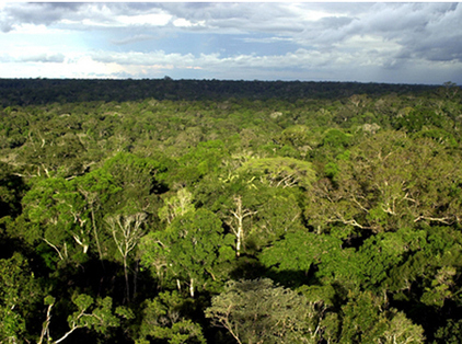
Forest degradation results mainly from burning in neighbouring deforested areas from which fires escape control to become forest fires. These events are intensified by the combined effect of logging and climate change, jeopardizing the conservation of the Amazon rainforest and its ecosystem services. Logging, both in authorized management plans and through illegal activities, increases the vulnerability of the forest to the entry and spread of forest fires. This is due to the increase in combustible material that results from collateral damage caused by the logging and dragging processes. Logging also opens the canopy, allowing entry of more radiation and increasing the intensity of wind, thus making the local microclimate warmer and drier. Climate change, which has already been observed in some parts of the Amazon, causes a lengthening of the dry season and increases the frequency of extreme droughts, directly affecting the occurrence of forest fires. The general objective of the project, therefore, is to provide a diagnosis and prognosis of forest degradation caused by logging and by forest fires resulting from burning in cleared areas. The project will generate scenarios that can aid in preventive control of burning and provide information for the management of natural resources and conservation areas.
PIs: Liana Oighenstein Anderson (Cemaden/FAPESP) and Philip M. Fearnside (INPA/FAPEAM).
Associated Researches:
Luiz Eduardo Oliveira e Cruz de Aragão (INPE)
Paulo Maurício Lima Alencastro Graça (INPA)
Aurora Miho Yanai Nascimento* (INPA)
Chantelle Burton (MetOffice)
Richard Betts (MetOffice)
Chris Jones (MetOffice)
Technical team:
Nathália Silva de Carvalho – PhD student (INPE)
Ana Carolina Pessôa - PhD student (INPE)
Celso Henrique Silva Júnior - PhD student (INPE)
Henrique Cassol - PosDoc (INPE)
João dos Reis – Research Assistent (Cemaden)
Project summary:
Forest degradation results mainly from burning in neighbouring deforested areas from which fires escape control to become forest fires. These events are intensified by the combined effect of logging and climate change, jeopardizing the conservation of the Amazon rainforest and its ecosystem services. Logging, both in authorized management plans and through illegal activities, increases the vulnerability of the forest to the entry and spread of forest fires. This is due to the increase in combustible material that results from collateral damage caused by the logging and dragging processes. Logging also opens the canopy, allowing entry of more radiation and increasing the intensity of wind, thus making the local microclimate warmer and drier. Climate change, which has already been observed in some parts of the Amazon, causes a lengthening of the dry season and increases the frequency of extreme droughts, directly affecting the occurrence of forest fires. The general objective of the project, therefore, is to provide a diagnosis and prognosis of forest degradation caused by logging and by forest fires resulting from burning in cleared areas. The project will generate scenarios that can aid in preventive control of burning and provide information for the management of natural resources and conservation areas.
2019-2022 Multi-Actor Adaptation Plan to cope with Forests under Increasing Risk of Extensive fires (MAP-FIRE)
Project website:https://www.treeslab.org/map-fire.html
Funding Agency: Inter-American Institute for Global Change Research (IAI), process: SGP-HW 016.
Principal investigator (PI):
• Liana Oighenstein Anderson
Co-PIs:
Working Package 1: Aragão and Selaya
• Luiz Eduardo O. C. de Aragão, INPE, Brazil
• Galia Selaya, HERENCIA, Cobija, Bolivia.
Working Package 2: Marchezini and Ascorra
• Victor Marchezini, Cemaden, Brazil.
• César Ascorra, Asociación CINCIA, Puerto Maldonado, Peru.
Working Package 3: Rioja and Anderson
• Guillermo Rioja-Ballivian, Universidad Amazónica de Pando, Cobija, Bolivia.
Project partners:
Researchers: Irwin Foster Brown, Woods Hole Research Center, USA, and Federal University of Acre, Rio Branco, Brazil. Peru: Eddy Mendoza, Fundación Conservación Internacional, Lima, Perú. Francisco Roman, Asociacion CINCIA, Madre de Dios, Peru. Martin Pillaca, Asociacion CINCIA, Madre de Dios, Peru. Brazil: Thiago Fonseca Morello Ramalho da Silva, Centre for Engineering, Modelling and Applied Social Sciences (CECS), Federal University of ABC, São Paulo, Brazil. Sonaira Souza da Silva, Universidade Federal do Acre, Campus Cruzeiro do Sul.
Stakeholders: Brazil: Vera Reis, Coordinator of the Situation Room, Technical Director of Climate Change Institute (IMC), Acre State Secretary of Environmental Management – SEMA. Carlos Edgard de Deus, State Secretary for the Environment, Acre state. Peru: Claudio Schneider, Senior Technical Director, Fundación Conservación Internacional, Lima, Peru. Bolivia: Juan Fernando Reyes, HERENCIA,Cobija, Pando, Bolivia. C
Students and Research fellows: Ana Carolina Pessôa - 2nd year PhD student with scholarship, supervised by Dr Liana Anderson; Wesley Campanharo - 3nd year PhD student with scholarship, supervised by Dr Liana Anderson and Dr Thiago Morello; Cândida Leite - 1st year MSc student with scholarship, supervised by Dr Liana Anderson (2019-2021); João dos Reis - Research Assistant with scholarship, supervised by Dr Liana Anderson.
**One main output of the MAP-Fire project team is the MAP-Fire fire monitoring and management online tool for disaster risk reduction and impact quantification associated with wildfires in the MAP region (details below). This Platform, with free access, indicates when and where is burning, based on satellite fire pixels , and also what is burning, through the combination of fire data with land use and land cover. One can also identify who is burning, by identifying the fire location in relation to the land tenure (conservation area, indigenous land, private rural properties, union´s land, etc). The location of schools and health infrastructures are also present and one can assess the exposure of these places to fire occurrence.
Check the Platform at: http://www.terrama2.dpi.inpe.br/acre/monitor/
The tutorial is available at: https://www.treeslab.org/products.html
Support:
*Inter-American Institute for Global Change Research (IAI), process: SGP-HW 016.
*National Council for Scientific and Technological Development (Conselho Nacional de Desenvolvimento Científico e Tecnológico)CNPq, process 300068/2019-0.
*UK BR Science Impact Acceleration House - Newton Fund.
2018-2020 - An early warning system to subsidize planning and decision making for mitigating wildfires in tri-national frontier, MAP-region, southwestern Amazonia: the MAP-Fire Platform
Project product webpage: https://www.treeslab.org/products.html
Funding Agency: CNPq - process 300068/2019-0, Bolsa de Programa de Capacitação Institucional DB/Cemaden.
Coordinator: Liana Oighenstein Anderson
Assistant researcher: Dr João Bosco Coura dos Reis
Collaborators: Eymar Lopes, Luiz Aragão (INPE).
We have been awarded with the 2019 UK BR Science Impact Acceleration House - Embaixada Britânica do Brasil Newton Fund, to accelerate the societal impact of this research and development project.
The MAP-Fire fire monitoring and management online tool for disaster risk reduction and impact quantification associated with wildfires in the MAP region (details below). This Platform, with free access, indicates when and where is burning, based on satellite fire pixels , and also what is burning, through the combination of fire data with land use and land cover. One can also identify who is burning, by identifying the fire location in relation to the land tenure (conservation area, indigenous land, private rural properties, union´s land, etc). The location of schools and health infrastructures are also present and one can assess the exposure of these places to fire occurrence.
2019-2021: SEM-FLAMA: Soluções para reduzir os impactos socioambientais do fogo EM FLorestas AMAzônicas de Uso Sustentável
Os principais objetivos do Projeto SEM-FLAMA são (1) compreender as relações entre as práticas de manejo do fogo, os incêndios florestais e suas consequências socioculturais e ecológicas em duas florestas protegidas e de uso sustentável onde o risco e frequência de incêndios tem aumentado expressivamente nos últimos anos: Floresta Nacional dos Tapajós e Reserva Extrativista Tapajós-Arapiuns - veja carta de apoio dos respectivos gestores; e (2) utilizar ações participativas e educacionais que integrem os conhecimentos de cunho sociocultural e ecológico para fomentar o manejo integrado do fogo e a gestão destas unidades de conservação, através do fortalecimento de sua capacidade de resposta e realização de intervenções por atores locais em
relação aos incêndios florestais.
Funding Agency: CNPq/Prevfogo - Ibama Nº 33/2018, processo: 441949/2018-5.
Team:
Dra. Joice Ferreira, PI, EMBRAPA Amazônia Oriental;
Dra. Liana O. Anderson, Cemaden;
Dr. Luiz Aragão, INPE;
Dr. João dos Reis, Cemaden;
Dra.Angela Stewards, UFPA;
Dra. Emilie Coudel, CCIRAD, França;
Dra.Lucineide Pinheiro, UFOPA;
Dra. Rachel Carmenta, Universidade de Cambridge (Reino Unido);
Dra. Rachel Trajber, Cemaden;
M.A. Thiago Medaglia, jornalista, fundador e editor da Ambiental Media;
Dr. Alexander Lees, Manchester Metropolitan University;
Dra. Erika Berenguer, Universidade de Oxford;
Dr. Fernando Vaz-de-Mello, UNEMAT;
Dr. Filipe França, pós-doutorando no âmbito do PELD-RAS;
Dr. Jos Barlow, Lancaster Environment Centre (Reino Unido);
Msc. Liana Rossi, bolsista do PELD-RAS e aluna de Doutorado na UNESP;
Marco A. Pizo Ferreira, UNESP;
Dr. Nárgila Moura, Museu Goeldi.
2020-2021: Avaliação dados ambientais e sociais para mitigação de riscos de incêndios florestais na FLONA Tapajós e RESEX Tapajós-Arapiuns, Pará, Brasil
Durante o El Niño em 2015-16, a região de Santarém foi fortemente afetada por incêndios florestais, impactando uma área de cerca de 1 milhão de hectares de florestas primárias e 20 mil hectares de florestas secundárias. Especificamente, na Floresta Nacional (FLONA) Tapajós e na Reserva Extrativista (RESEX) Tapajós-Arapiuns, áreas de interesse deste projeto, tiveram aproximadamente 12% e 23% de suas áreas afetadas por estes incêndios florestais, respectivamente. Portanto, o entendimento da dinâmica do uso do fogo, e as consequências socioambientais que a perda de seu controle geram, são chave para contribuir com a criação de estratégias de gestão do risco destes desastres. Este projeto tem o objetivo de avaliar as consequências socioambientais do uso do fogo e perda de seu controle em comunidades tradicionais da FLONA Tapajós e RESEX Tapajós-Arapiuns, a partir da integração de dados de sensoriamento remoto e dado socioculturais coletado em campo.
Funding Agency: FUNBIO, processo 089/2019
Team:
Dr. Liana O. Anderson, PI, Cemaden.
MSc Ana Larissa de Freitas, aluna de Mestrado do curso de Pós-graduação em Sensoriamento Remoto do INPE.
More infor abou this project can be found in this very nice video:
https://www.youtube.com/watch?v=hk-9htk8epI&feature=youtu.be
Bolsas FUNBIO | Conservando o Futuro: Ana Ribeiro
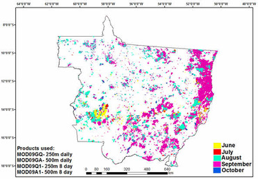
2019-2021: Incêndios florestais e queimadas no Estado do Acre: análise da extensão, nível de degradação e cenários futuros
O Estado do Acre foi epicentro de três grandes secas nos últimos 15 anos, em 2005, 2010 e 2016, condição climática extrema nunca registrada em 30 anos de monitoramento. Estas secas favoreceram a ocorrência de grandes incêndios em paisagens agrícolas como também na floresta. Este projeto de pesquisa possuiu objetivos:
•Analisar e diagnosticar, de maneira integral, das queimadas e incêndios florestais em escala temporal e espacial. O cerne do desafio está em estimar, de forma comparável (i.e., com a mesma unidade de medida) e em escala espacial que permita o gestor a tomada de decisão como limites políticos, categorias fundiárias ou até mesmo local e forma precisa e confiável ao longo do tempo. Mapeamento sistemático como este atualmente vemos no monitoramento do desmatamento na Amazônia e no mapeamento recente e inovador os incêndios florestais no Estado do Acre coordenado pela Dra. Sonaira Souza da Silva dos incêndios florestais no Estado do Acre;
•Mensurar o custo-benefício de substituir parcial ou totalmente o fogo agrícolano Acre. Levantamento desta natureza somente foi feito na região do Baixo Acre pelo Dr Thiago Fonseca Morello (UFABC). Esta informação é uma grande lacuna científica e social, pois são cobradas mudanças no modelo de desenvolvimento agrícola do Estado, entretanto com poucas alternativas viáveis em função da demanda social local. Por diversos anos (2009, 2011, 2012) o Ministério Público do Acre tentou impedir por força de ação civil a ocorrência de queimadas no Acre, entretanto, sem resultados efetivos como mostra a Figura 1.
•Mensurar o nível de degradação florestal causado pelo fogo considerando o tempo após a degradação e a reincidência do fogo.
•Mensurar o risco de queimadas a partir da modelagem espacial com linguagem de programação e construção de plataforma web para disponibilização de todos os resultados do projeto. Trata-se de um desafio tecnológico para a realidade amazônica, entretanto que pode trazer benefícios públicos com o empoderamento da sociedade sobre informações científicas e uso dessas informações para tomadas de decisão de políticas públicas.
Funding Agency: CNPq/Prevfogo - Ibama Nº 33/2018, processo: 442650/2018-3.
Team:
Sonaira Souza da Silva, PI, UFAC;
Antonio Willian Flores de Melo, UFAC;
Tiago Lucena da Silva, UFAC;
Igor Soares de Oliveira, UFAC;
Marcus Vinicius de Athaydes Liesenfeld, UFAC;
Marllus Rafael Negreiros de Almeida, UFAC;
Francisco Salatiel Clemente de Souza, UFAC;
Liana Oighenstein Anderson, Cemaden;
Luiz Eduardo Oliveira e Cruz de Aragão, INPE;
Paulo Maurício Lima de Alencastro Graça, INPA;
Philip Martin Fearnside, INPA;
Thiago Fonseca Morello Ramalho da Silva, UFABC;
Ane Alencar, IPAM;
Paulo Monteiro Brando, WHRC;
Irving Foster Brown, WHRC/UFAC
2019-2021 Agri-environmental policy and agricultural fires in the Amazon: an economic analysis
Agricultural fires and forest fires are among the main sources of emissions of greenhouse gases and pollutants in the Brazilian Amazon. The agri-environmental policy in vigour has proved limited to contain fires, a gap that tends to be expanded by the current trends of a regional climate more favorable to the spread of fire and the reduction of the public budget for environmental protection. The research aims to contribute to increase the efficiency and equity with which the current policy instruments affect emissions from fires. To this end, multiple potential public policy improvements will be evaluated, first based on a cost-effectiveness analysis, which will combine techniques of (i) inference of individual preferences and (ii) statistical modelling of the health impacts of fires. In addition, a long-term analysis of the social distribution of costs and benefits generated by policy will be conducted, through the computational simulation of governmental and private decisions. This double methodological framework is innovative for integrating non-market valuation, remote sensing and statistical techniques, connecting efficiency and equity, supply and demand for environmental services and short and long term perspectives. Two Amazon states will be studied, Acre and Mato Grosso.
Funding Agency: FAPESP, Grant number: 19/05440-5
Team:
Thiago Fonseca Morello Ramalho da Silva, PI, UFABC
Demerval Soares Moreira, UNESP
Leonela Guimarães da Silva, UFMT
Liana Oighenstein Anderson, Cemaden
Rubicleis Gomes da Silva, UFAC
Sonaira Souza Silva, UFAC
Funding Agency: FAPESP, Grant number: 19/05440-5
Team:
Thiago Fonseca Morello Ramalho da Silva, PI, UFABC
Demerval Soares Moreira, UNESP
Leonela Guimarães da Silva, UFMT
Liana Oighenstein Anderson, Cemaden
Rubicleis Gomes da Silva, UFAC
Sonaira Souza Silva, UFAC
2019-2021 Tecnologias educacionais inovadoras para abordagem interdisciplinar na redução de risco de desastres socioambientais
O presente projeto tem como objetivo geral, desenvolver e avaliar materiais e metodologias inovadoras para uso e aplicação de dados ambientais visando a abordagem interdisciplinar, com ênfase em um sistema de monitoramento e alertas para redução do risco de desastres. Listam-se abaixo os objetivos específicos (OE):
OE1. Introduzir os conceitos relacionados ao tema de RRD em sala de aula, promovendo uma cultura de prevenção de desastres..
Metas: - Formação de professores e alunos para coleta de dados de precipitação através de 2 oficinas de pluviômetros pet.
- Implantação de 1 plataforma de monitoramento integrado de desastres e impactos.
- Produção de 1 jogo RPG sobre sistema de alertas de desastres relacionados a deslizamentos, inundações e incêndios.
OE2. Estimular o uso de dados ambientais para potencializar o ensino interdisciplinar de Geografia, Ciências, Matemática e Português, utilizando metodologias participativas.
Meta: - Produção de 1 maquete caixa de areia contendo camada de informação referente a temática de desastres.
OE3. Incentivar o desenvolvimento de pesquisa científica por alunos do ensino fundamental e médio.
Meta: - Produção de 40 boletins semanais pelos alunos sobre monitoramento integrado da precipitação, qualidade de ar, focos de calor na escala local da escola.
OE4. Promover maior engajamento da comunidade acadêmica e científica junto à comunidade escolar.
Meta: - Produção de 3 artigos em parceria com professores da EEDHBS, de pesquisadores do Cemaden e professores da Univap.
Funding Agency: MCTIC/CNPq nº 05/2019 - Edital Ciência na Escola, processo: 440702/2019-4.
Team:
Silvia Midori Saito, PI, Cemaden
Adriane Aparecida Moreira de Souza, Univap
Anamaria da Silva Martin Gascon Oliveira, Univap
Carla Correa Prieto, Cemaden
Felipe Gonçalves de Arruda, Escola Estadual Diácono Hamilton Bontorim de Souza
Francisco Carlos da Silva Dias, Escola Estadual Diácono Hamilton Bontorim de Souza
Graziela Balda Scofield, Cemaden
João Bosco Coura dos Reis, Cemaden
Jobair Assis Rangel, Escola Estadual Diácono Hamilton Bontorim de Souza
José César de Souza, Escola Estadual Diácono Hamilton Bontorim de Souza
Liana O. Anderson, Cemaden
Maria Francisca Velloso, Cemaden
Nádia Maria Rodrigues de Campos Velho, Univap
Sandra Maria Fonseca da Costa, Univap
Rachel Trajber, Cemaden
Renato Santos Lacerda, Cemaden
2019 - 2021 Attributing Amazon Forest fires from Land-use Alteration and Meteorological Extremes (AFLAME)
Funding Agency: Newton Fund - Met Office UK, CSSP-Brazil
This project will deliver five key desired outcomes:
- Co-produce with INPE collaborators policy relevant research that can then be used by INPE scientists to inform relevant organisations as appropriate.
- Produce peer-reviewed publications on wildfire risk in the Amazon.
- Feedback to the Met Office any identified Amazon wildfire shortcomings of JULES-TRIFFID-INFERNO, with contribution of a modified code in the fire module.
- Train Brazilian scientists in how to perform an impact relevant attribution study in the context of large-scale atmospheric dynamical drivers.
- Establish and strengthen collaborations between Brazilian and UK scientists.
Team:
Dr. Sarah Sparrow, University of Oxford, UK
Prof. Yadvinder Malhi, University of Oxford, UK
Dr. Scott Osprey, University of Oxford, UK
Dr. Sihan Li, University of Oxford, UK
Dr. Sami Rifai - University of Oxford, UK
Dr. Liana Anderson, Cemaden
Dr Manuel Crdoso, INPE
Dr. Sarah Sparrow, University of Oxford, UK
Prof. Yadvinder Malhi, University of Oxford, UK
Dr. Scott Osprey, University of Oxford, UK
Dr. Sihan Li, University of Oxford, UK
Dr. Sami Rifai - University of Oxford, UK
Dr. Liana Anderson, Cemaden
Dr Manuel Crdoso, INPE
2018-2022 Waterproofing Data: Engaging Stakeholders in Sustainable Flood Risk Governance for Urban Resilience
Fund:
Economic and Social Sciences Research Council - ESRC- UK: ES/S006982/1
São Paulo Research Foundation - FAPESP - Brazil: 2018/50039-4
German Federal Ministry of Education and Research (BMBF)
Economic and Social Sciences Research Council - ESRC- UK: ES/S006982/1
São Paulo Research Foundation - FAPESP - Brazil: 2018/50039-4
German Federal Ministry of Education and Research (BMBF)
Waterproofing Data investigates the governance of water-related risks, with a focus on social and cultural aspects of data practices. Typically, data flows up from local levels to scientific "centres of expertise", and then flood-related alerts and interventions flow back down through local governments and into communities. Rethinking how flood-related data is produced, and how it flows, can help build sustainable, flood resilient communities.
To this end, this project develops three innovative methods around data practices, across different sites and scales:
The project will be conducted by a highly skilled international team of researchers with multiple disciplinary backgrounds from Brazil, Germany and the UK, in close partnership with researchers, stakeholders and the public of a multi-site case study on flood risk management in Brazil. Furthermore, the methods and results of this case study will be the basis for a transcultural dialogue with government organisations and local administration involved in flood risk management in Germany and the United Kingdom.
Waterproofing Data brings together an interdisciplinary group of researchers and institutions from the three collaborating countries, United Kingdom, Brazil and Germany, through the funding of around €1m, provided by an international association of research councils: Economic and Social Sciences Research Council (ESRC), São Paulo Research Foundation (FAPESP) and German Federal Ministry of Education and Research (BMBF), in collaboration with NORFACE, the Belmont Forum and the International Science Council within the Transformations to Sustainability (T2S) research programme.
>> Project launch<<
Team:
João Porto Albuquerque, PI, University of Warwick, UK
Maria Alexandra Cunha, Co-PI, Getulio Vargas Foundation, Brazil
Alexander Zipf, Co-PI, Heidelberg University, Germany
Carolin Klonner, Heidelberg University
Conrado Rudorff, CEMADEN
Joanne Garde Hansen, University of Warwick
Jon Coaffee, University of Warwick
Liana Oighenstein Anderson, CEMADEN
Nathaniel Tkacz, University of Warwick
Nerea Calvillo Gonzalez, University of Warwick
Rachel Trajber, CEMADEN
Vangelis Pitidis, University of Warwick
Victor Marchezini, CEMADEN
To this end, this project develops three innovative methods around data practices, across different sites and scales:
- Making visible existing flows of flood-related data through tracing data;
- Generating new types of data at the local level by engaging citizens through the creation of multimodal interfaces, which sense, collect and communicate flood data, and;
- Integrating citizen-generated data with other data using geo-computational techniques.
The project will be conducted by a highly skilled international team of researchers with multiple disciplinary backgrounds from Brazil, Germany and the UK, in close partnership with researchers, stakeholders and the public of a multi-site case study on flood risk management in Brazil. Furthermore, the methods and results of this case study will be the basis for a transcultural dialogue with government organisations and local administration involved in flood risk management in Germany and the United Kingdom.
Waterproofing Data brings together an interdisciplinary group of researchers and institutions from the three collaborating countries, United Kingdom, Brazil and Germany, through the funding of around €1m, provided by an international association of research councils: Economic and Social Sciences Research Council (ESRC), São Paulo Research Foundation (FAPESP) and German Federal Ministry of Education and Research (BMBF), in collaboration with NORFACE, the Belmont Forum and the International Science Council within the Transformations to Sustainability (T2S) research programme.
>> Project launch<<
Team:
João Porto Albuquerque, PI, University of Warwick, UK
Maria Alexandra Cunha, Co-PI, Getulio Vargas Foundation, Brazil
Alexander Zipf, Co-PI, Heidelberg University, Germany
Carolin Klonner, Heidelberg University
Conrado Rudorff, CEMADEN
Joanne Garde Hansen, University of Warwick
Jon Coaffee, University of Warwick
Liana Oighenstein Anderson, CEMADEN
Nathaniel Tkacz, University of Warwick
Nerea Calvillo Gonzalez, University of Warwick
Rachel Trajber, CEMADEN
Vangelis Pitidis, University of Warwick
Victor Marchezini, CEMADEN
2018-2022: Interannual variation of Amazon Basin greenhouse gas balances and their controls in a warming and increasingly variable climate - Carbam - the Amazon Carbon Balance Long-term Study
The main propose is to determine the fate of the carbon sink and methane source of the Amazon Basin in a period during which the Basin is likely to experience a warming and increasingly variable climate, as well as increasing direct human pressure. This will be done primarily by regularly measuring vertical profiles of atmospheric greenhouse gas concentrations over the Basin. Our previous work, published recently in Nature (Gatti et al. 2014), demonstrated that the Amazonian carbon balance is sensitive to dry versus wet years. The limited period covered by our data does, however, not yet permit to tell us what the Amazon Basin carbon balance will be in the decades to come. Our proposed strategy is therefore to continue the proven method of regular basin-wide vertical profile greenhouse gas measurements to complete one decade, and expand it with important new capabilities. First, we will add COS and 13CO2, to our existing suite of measured gases, which will permit an improved understanding of unusually dry and hot conditions on forest functioning. Furthermore we propose to complement the vertical bi-weekly profile sampling with continuous greenhouse gas measurements at three intermediate to tall towers (65 and 310 m). Data analysis will rely on two high resolution regional models and two global models, state of the art land vegetation models to simulate CO2, COS and 13CO2, and three state-of-the-art inverse modeling approaches (Lagrangian, 4D-variational, and ensemble based) available via the participating partners. Together, these multiple approaches will give us a realistic assessment of the uncertainties of our Amazon Basin greenhouse balance estimates, as well as their trends and controls in a warming world and thereby an assessment of state and changes of the Amazon forests.
Fund: FAPESP, process 2016/02018-2.
Team:
Luciana Vanni Gatti, PI, INPE
Liana Oighenstein Anderson, CEMADEN
Allan Scott Denning, Colorado State University/CSU
Ana Paula Dutra de Aguiar, INPE;
Carlos Augusto Bauer Aquino, Campus Porto Velho Calama/IFROPVHC/IFRO
Celso von Randow, INPE
Christiane Silvestrini de Morais,Campus Porto Velho Calama/IFROPVHC/IFRO
Demerval Soares Moreira, Faculdade de Ciências de Bauru/FC/UNESP
Elliot Campbell, University of California, Merced/UCMERCED
Emanuel Gloor, University of Leeds
Ingrid Theodora van der Laan-Luijkx, Wageningen University & Research/WUR
Jean Pierre Henry Balbaud Ometto, INPE
John Bharat Miller, NOAA Earth System Research Laboratory/ESRL
John Michael Melack, University of California at Santa Barbara/UCSB
Jonathan Barichivich, Universidad Austral de Chile/UACH
Joseph Andrew Berry, Department of Global Ecology, Carnegie Institution for Science/DGE
Jost Valentin Lavric, Max-Planck-Gesellschaft/MPG
Kenia Teodoro Wiedemann,
Luiz Eduardo Oliveira e Cruz de Aragão, INPE;
Luana Santamaria Basso, Instituto de Ciências da Saúde/ICS/UNIP
Luciano Marani, INPE
Oliver Lawrence Phillips, UUniversity of Leeds
Osvaldo Luiz Leal de Moraes, Cemaden
Paulo Nobre, INPE
Plinio Carlos Alvalá, INPE
Saulo Ribeiro de Freitas, Goddard Space Flight Center/NASA/GSFC
Steven Charles Wofsy, Harvard University/HU
Wouter Peters, Wageningen University & Research/WUR
Caio Silvestre de Carvalho Correia
Lucas Gatti Domingues, INPE
Viviane Francisca Borges, Instituto de Pesquisas Energéticas e Nucleares/IPEN/SDECTSP
Ricardo Santana dos Santos
Stéphane Palma Crispim
Wellison Rodrigues da Costa
2017 - 2019: Mapping and monitoring forest degradation using remote sensing data with medium and moderate spatial resolution
This project presents a methodological approach for mapping and monitoring forest degraded areas due to selective logging and forest fires. In this context, the State of Mato Grosso was selected for the study area, a region that has several vegetation types and has suffered major changes in the land use and land cover due to the advance of agriculture in the cerrado regions, as well as the activities of deforestation and burning in the legal Amazon region, by natural or anthropogenic causes. For this, it will be used remote sensing images with medium spatial resolution of Landsat acquired during the years 2000 (TM), 2010 (TM) and 2015 (OLI). In addition, it will be used moderate spatial resolution images of MODIS (2001 to 2015) and PROBA-V (2015) sensors. The general objectives of this study are: 1) to develop a methodology for detection of degraded forest areas due to selective logging and burning; 2) to generate a land cover map of the region in a medium spatial resolution for the year 2015; 3) to generate maps of degraded forest areas for the study years; and 4) to analyse the fire incidence in deforested burned areas and to estimate the burned biomass and its greenhouse gases emitted into atmosphere. For the validation of the results it will be used high spatial resolution images from RapidEye, Sentinel-2 and LiDAR in test areas, and four field works will be carried out to support the image interpretations. The informations obtained by the project are important as a base for planning and management of natural resources in the region, as well as to improve the carbon emission estimates.
Fund: FAPESP, Grant number: 16/19806-3
Team:
Yosio Shimabukuro, PI, INPE
Egidio Arai, inpe
Francielle da Silva Cardozo, UFSJ
Gabriel Pereira, UFSJ
Liana Oighenstein Anderson, Cemaden
Luiz Eduardo Oliveira e Cruz de Aragão, INPE
Valdete Duarte, INPE
Team:
Yosio Shimabukuro, PI, INPE
Egidio Arai, inpe
Francielle da Silva Cardozo, UFSJ
Gabriel Pereira, UFSJ
Liana Oighenstein Anderson, Cemaden
Luiz Eduardo Oliveira e Cruz de Aragão, INPE
Valdete Duarte, INPE
2014-2018: Tropical Deforestation and Economic Development
Project web page:
https://www.nhh.no/en/research-centres/tropical-deforestation/
Fund: The Research Council of Norway (project number 230860)
PIs: Dr Torfinn Harding (Associate Professor, Norges Handelshøgskole, Noruega), Dr. Liana O. Anderson (Universidade de Oxford/INPE, Brasil), Dr. Karlygash Kuralbayeva (London School of Economics and Political Science (LSE), Reino Unido).
Collaborators: Mr. James Cust (PhD student, University of Oxford), Samantha De Martino (PhD student, University Sussex), Dr. André Lima, Leticia Kirsten Fernandes (research assistant - supervised by Liana Anderson).
2014-2018: Quantificação de áreas florestais queimadas e modelagem de emissões de carbono: Proposta de um sistema de monitoramento integrado para a Amazônia
Fund: CNPq, Processo: 458022/2013-6 Chamada: MCTI/CNPq/FNDCT – Ação Transversal - nº 68/2013 – Programa de Grande Escala da Biosfera-Atmosfera na Amazônia – LBA.
PIs: Dr. Luiz Aragão (INPE), Dr. Tiago Carneiro (UFOP), Dr. Joice Ferreira (EMBRAPA), Dr. Fabrício Silva (UniCEUMA), Dr. Haron Xaud (EMBRAPA), Dr. Paulo Graça (INPA), Dra. Liana O. Anderson (Universidade de Oxford/INPE).
Collaborators: Dr. Erika Berenguer (Universidade de Lancaster, Reino Unido), Dr. Bernard Barlow (Universidade de Lancaster, Reino Unido), Dr. Toby Gardner (Universidade Cambridge, Reino Unido), MSc. Valdete Duarte (INPE), Dr. Egidio Arai (INPE), Dra. Maristela Xaud (EMBRAPA), Dr. Raimundo Cosme Oliveira (EMBRAPA).
2014-2018: Drought-induced vegetation change and fire in Amazonian forests: past, present, and future
Fund: NASA and IDS Program (Interdisciplinary Research in Earth Sciences), Proposal number: 12-IDS12-0097, grant number: NNX14AD31G.
Dr. Michael Palace (University of New Hampshire), Dra. Crystal McMichael (University of New Hampshire), Dr. Michael Keller (USGS/EMBRAPA), Dr. Mark J Ducey (University of New Hampshire), Dr. Mark Bush (Florida Institute of Technology), Dr. Dar A. Roberts (University of California), Dr. Bobby Braswell (Applied-Geosolutions), Dr.Stephen Hagen (Applied-Geosolutions), Dr. Steve Frolking (University of New Hampshire), Dr. Michael Toomey (Harvard University), Dra. Heidi Asbjornsen (University of New Hampshire), Dr. Douglas Morton (NASA), Dr. Luiz Aragão (INPE), Dra. Liana O. Anderson (Universidade de Oxford/INPE).
2014-2018: Understanding the Response of Photosynthetic Metabolism in Tropical Forests to Seasonal Climate Variation
Fund: DOE (Departament of Energy, USA)
DE-FOA-0000919,
FAPESP 2013/50533-5
FAPEAM (Agência financiadora do Estado do Amazonas, Brasil). Call GoAmazon – 2014.
Dr. Denis Dye (U.S. Geological Survey, Estados Unidos), Dr. Scott R. Saleska (University of Arizona), Dr. Kenia Wiedemann (University of Arizona), Dr. Valeriy Ivanov (University of Michigan), Dr. Alfredo Huete (University of Arizona e University of Technology Sydney), Dr. Marciel J. Ferreira (PI) (Universidade Federal do Amazonas), Dr. Luiz Eduardo Oliveira e Cruz de Aragão (PI) (INPE), Dr. Liana Anderson (Universidade de Oxford/INPE).
Collaborators: Dr. José Francisco de C. Gonçalves (INPA), Dr. Bruce W. Nelson (INPA), Dr. Ricardo A. Marenco (INPA), Dr. Gilberto C. Justino (UFAL), Dr. Carlos Eduardo Moura da Silva (UFRR), Dr. Rafael Oliveira (UNICAMP), Dr. Yosio Edemir Shimabukuro (INPE), Dr. Egídio Arai, (INPE), Dr. Luciana Alves (IAC).
2014-2018: TOWARDS AN UNDERSTANDING OF TIPPING POINTS WITHIN TROPICAL SOUTH AMERICAN BIOMES
Website: www.e-tribes.com.br
Fund -FAPESP: 2013/50169-1
PI Dr. Ricardo da Silva Torres (UNICAMP).
Associated Researches: Dr Marina Hirota Magalhães (UFSC), Dr Rafael Silva Oliveira (UNICAMP), Dr Jan Verbesselt (Wageningen University and Research Center), Dr Ingrid van de Leemput (Wageningen University and Research Center), Dr Vasilis Dakos (Estación Biológica de Doñana), Dr Jefersson A dos Santos (UNICAMP).
Collaborators: Dr Liana O. Anderson (Cemaden), Dr Tiago Carvalho (Cemaden).
Projeto Pan-Amazônia II. Mapeamento intra-anual de cicatrizes de áreas queimadas, mapeamento da lâmina d´água e mapeamento multi-decadal do uso e cobertura da terra.
http://www.dsr.inpe.br/laf/panamazonia/index.html
Equipe – DSR/INPE: Valdete Duarte, Yosio Shimabukuro, Roberto Martini, Liana Anderson, Egidio Arai, Otton Bastos, Luiz Aragão.
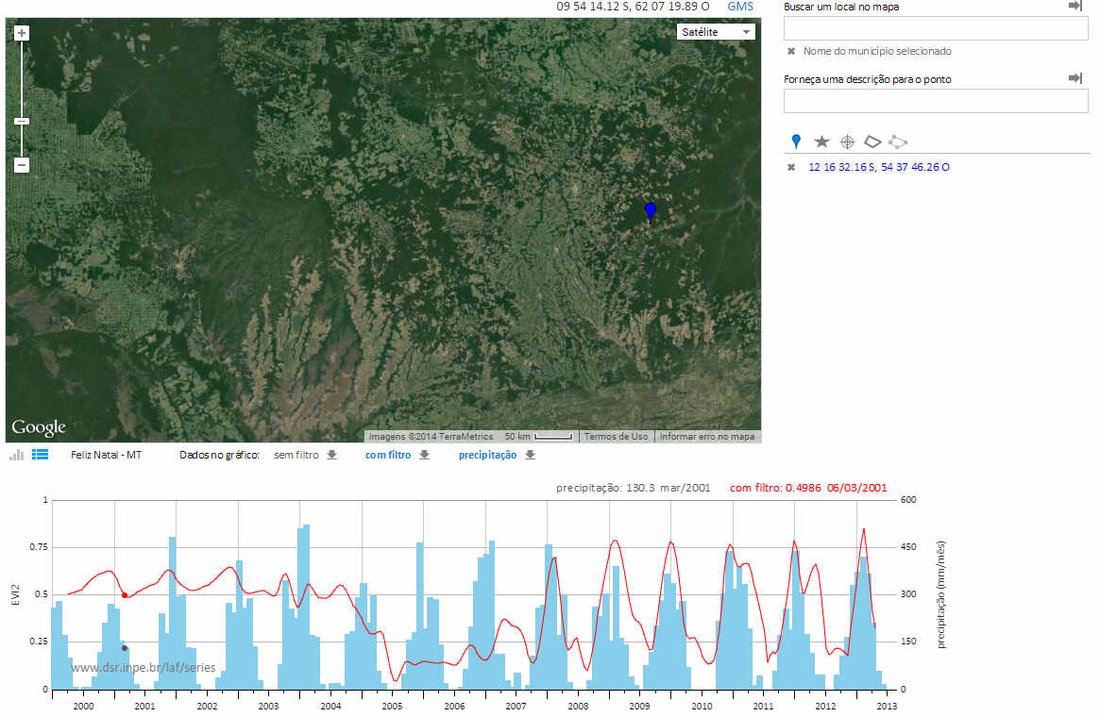
Projeto Laboratório Virtual. Ferramenta de visualização de dados multitemporais em uma plataforma web acoplada a Google engine
https://www.dsr.inpe.br/laf/series/
Coordenadores: Egidio Arai e Yosio Edemir Shimabukuro. Concepção, desenvolvimento e análise das Séries Temporais: Ramon Morais de Freitas. Produtos e validação: Liana Oighenstein Anderson, Luiz Eduardo Oliveira e Cruz de Aragão, Marcos Adami e Valdete Duarte.
http://www.dsr.inpe.br/laf/panamazonia/index.html
Equipe – DSR/INPE: Valdete Duarte, Yosio Shimabukuro, Roberto Martini, Liana Anderson, Egidio Arai, Otton Bastos, Luiz Aragão.
Projeto Laboratório Virtual. Ferramenta de visualização de dados multitemporais em uma plataforma web acoplada a Google engine
https://www.dsr.inpe.br/laf/series/
Coordenadores: Egidio Arai e Yosio Edemir Shimabukuro. Concepção, desenvolvimento e análise das Séries Temporais: Ramon Morais de Freitas. Produtos e validação: Liana Oighenstein Anderson, Luiz Eduardo Oliveira e Cruz de Aragão, Marcos Adami e Valdete Duarte.